
The One Chichen Itza Street View Figure That Has People Doing a Double Take
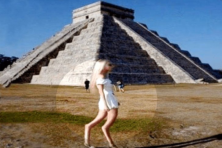
Google Maps Street View usually aids in finding locations but occasionally reveals peculiarities. Among the Mayan ruins at Chichen Itza in Mexico, a strange snapshot confounds viewers. A blonde woman appears as an ordinary tourist, yet the scene grabs attention unexpectedly.
She sports long blond hair, a short white dress, flat shoes, and sunglasses. Her head looks large compared to her slim body, with mismatched proportions resembling a pasted cutout. This oddity has puzzled users; some blame camera stitching, others find it stranger, and a few jest she might not be “from around here.”
This Giant Face in the Chilean Desert Has a Wild Backstory
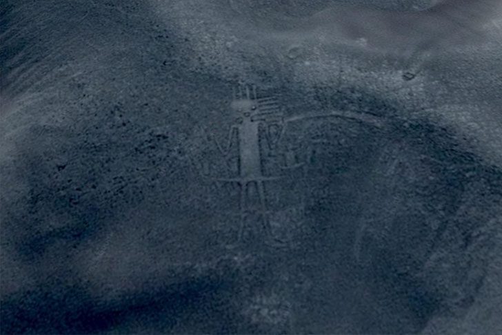
For years, massive, mysterious land art has been the kind of thing people love to blame on aliens. You spot a huge figure carved into the earth, your brain goes straight to, “Okay, who from outer space signed this?” That’s exactly the vibe with this giant near Huara, Chile, a towering hillside drawing that looks like a big, friendly character, until you stare a little too long and it starts feeling like it’s staring back. It’s the sort of desert “portrait” that can flip from fascinating to slightly nightmare fuel in about two seconds.
It’s probably not an intergalactic self-portrait, but here’s the twist, nobody really seems to know who made it or what the original purpose was. And that mystery is half the fun. The figure is so large you can pick it out clearly in satellite images on Google Earth, which tells you it was not a casual afternoon doodle. Someone put serious time, planning, and effort into carving those lines into the landscape. Whether it was meant as art, a marker, or something else entirely, it’s still quietly looming out there, keeping its secrets.
The One Google Street View Spot That’s Basically a Lava Lake
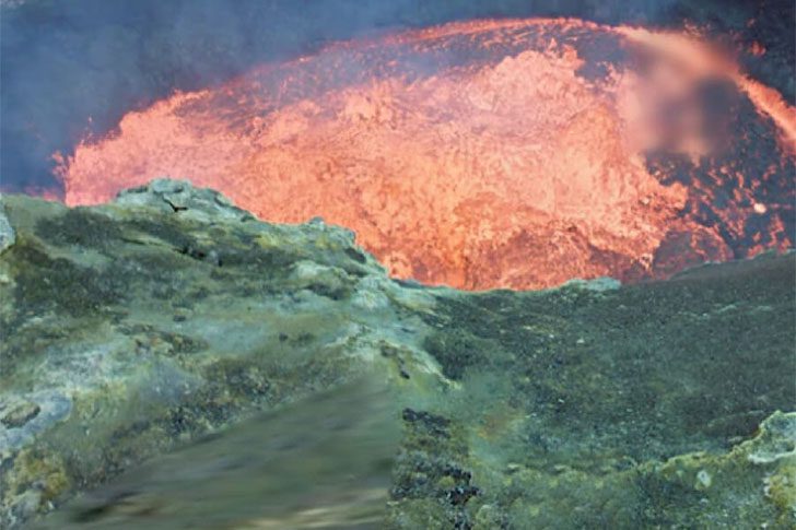
Ambrym, a volcano in Vanuatu, is renowned for its frequent eruptions, consistent rumbling, and astonishing lava lakes. Google integrated this into Street View, letting people virtually explore this thrilling and educational site. It's a stark reminder of Earth's wild, isolated places, with glowing heat, no crowds or guardrails.
LiveScience reports two explorers used 360-degree cameras to survey the lava lake's rim, creating a unique experience. Follow their Street View path to see the landscape transform as they near the fiery surface. For perspective, a satellite image reveals huge, bright red lava pools cutting into the volcano.
The One Photo From Sonora That’ll Make You Double-Check Your Door Locks
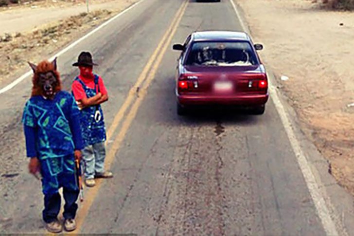
This snapshot from Sonora, northwest Mexico, resembles a horror movie set. A crew of masked figures is seen, including some with the famous Scream face and a werewolf-looking character. Notably, this region is linked to the brutal Los Zetas. It feels like a movie still, but it's real life.
There are two unsettling scenarios: they're either Furries missing the “playful” essence or actual serial killers. No middle ground exists. If joining the furry scene, choose a mask expressing “fun” rather than “nightmare fuel.” This look, unfortunately, radiates pure bad energy.
The One Café Chair in Sheffield That Made Everyone Look Twice
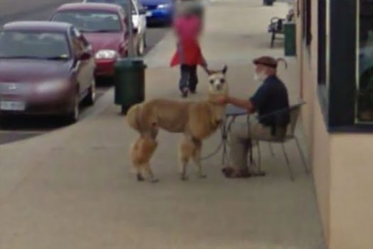
If you’ve spent any time clicking around maps and street views, you know the internet loves serving up little “wait, what?” moments. Sheffield, Tasmania delivered one of those gems. It shows a sunny day where people enjoy browsing and strolling about. Everything seems normal, which makes the surprise even more striking.
Outside the café, a guy sits in a chair as if he owns the afternoon, looking like any other customer, casually watching the street. But the scene takes a turn, quietly challenging the usual “dogs and cats are the best pets” notion. If you’ve never experienced an alpaca cuddle, you might be missing out on the coziest kind of chaos.
Why Is This VW Bus Glowing Like That?
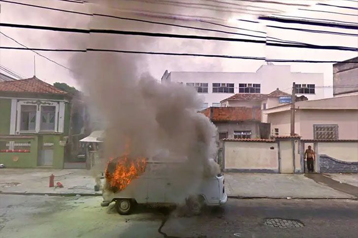
Heraclitus once said the only constant is change, and he probably wasn’t envisioning a VW bus turning into charcoal. Here, a flaming vehicle is observed alongside a shirtless guy standing as if it’s just another Tuesday. No panic, no drama, just calm acceptance while the van crackles and smokes like it belongs in a disaster movie.
Ever look at your car and think, "This thing is a heap"? You're still better off than this poor ride, which has had a rough day, to say the least. Sure, it's bright, but in the worst way—a warning sign you can't ignore. And yes, it's hot, but not in the fun sense—more like the kind that makes you back up fast and rethink every decision that led you to it.
The One Cleveland House Google Still Keeps Blurry
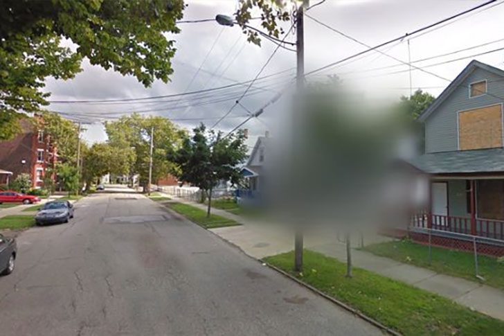
Stick a camera on top of a Google Maps car and send it cruising through neighborhoods, and you'll catch some weird moments. Most are harmless, even funny, like people waving or pets being silly. But sometimes, the camera captures something disturbing, leading Google to blur it. One such blur zone is on a working-class street in Cleveland, Ohio, where a certain man's former house once stood.
For nearly a decade, he kept three women captive in that home, fathering a child with one of them until an escape unravelled it all. Following his arrest and conviction, he died by suicide in prison. Although the house has been demolished, the area remains blurred on Street View, as if the map still wants to look away.
What Really Happened to the Costa Concordia Wreck?
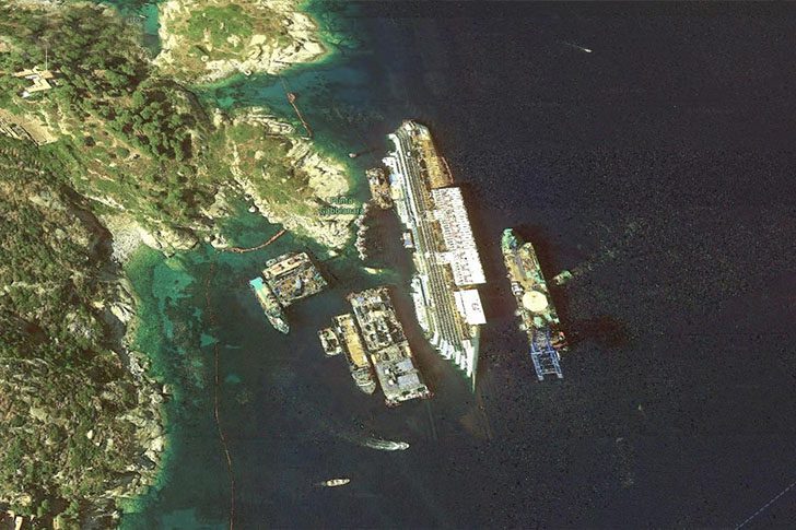
The Concordia ended up half-submerged off Italy’s coast in 2012 after striking an underwater rock near Isola del Giglio, just off Tuscany. This photo captures the massive salvage effort, when crews were still working to stabilize and recover the ship. Even from above, the wreck was impossible to miss. It’s a dramatic image and a sobering reminder of how quickly a routine cruise can become a headline-making catastrophe.
Years later, the story didn’t end with the ship being moved. The remaining debris has been dismantled in Genoa, long after global news covered the initial rescue. Seeing that twisted, rust-stained metal in pieces turns a famous wreck into something painfully real and final. The doomed vessel has often been described as Italy’s worst maritime disaster since World War II, until it was finally taken apart.
The Giant Chalk Lion on Google Earth, and Why It’s There
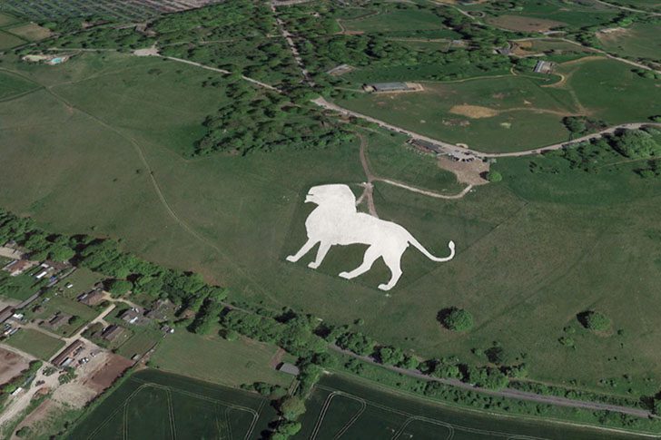
People exploring Google Earth stumbled onto something storybook-like, a huge lion etched into a chalk hillside. Locals always knew about it, but satellite views made it an accidental celebrity, with folks dubbing it “The Lion King.” It's in open farmland near Dunstable, UK. Once you see it, you may zoom in again to ensure your eyes aren’t playing tricks.
According to the BBC, the lion stretches about 483 feet, the largest hill figure in England. It overlooks Dunstable Downs toward Whipsnade Zoo, Bedfordshire. The idea was practical: a warning for low-flying planes, alerting pilots that the zoo was near to prevent aircraft noise from spooking animals. Not bad for a landmark now doubling as a Google Earth Easter egg.
The Google Earth Screenshot That Made Everyone Ask, “Wait, Is That E.T.?”
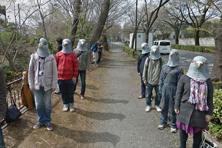
Ever wondered where the extraterrestrial ended up? Google Earth might have an unsettling clue. While exploring Japan's street views, users found a scene reminiscent of a low-budget sci-fi film. The image reveals eight figures, standing in line, eerily staring at the Google camera, prompting it to go viral for its bizarrely hilarious yet creepy vibe.
Pigeon role-play is known in Japan, but this snapshot's creepiness remains. In July 2013, Redditor bawsinmymouth shared the exact Musashino, Japan spot. What appears as a peaceful path hosts a "flock" of bird people just idly present. No movement, no explanation—just strange, unsettling vibes.
The Weirdest Thing a Google Street View Car Caught, a Wreck in Real Time

Google Maps cars frequently stumble into wild moments. Their constant block-by-block cruising captures everything from terrifying scenes to laughable absurdities. This allows us to “travel” the world from home, revealing chaotic instances nobody intended to share.
This image epitomizes such instances: a car accident captured in real-time. The vehicle arrived at exactly the right (or wrong) moment, freezing the scene for all to eventually discover. Google reported late-2019 numbers explaining the scale of this vast operation, which sometimes results in strange effects like this.
This Is What Happens to a Lawn When a Jet Fires Up Behind It
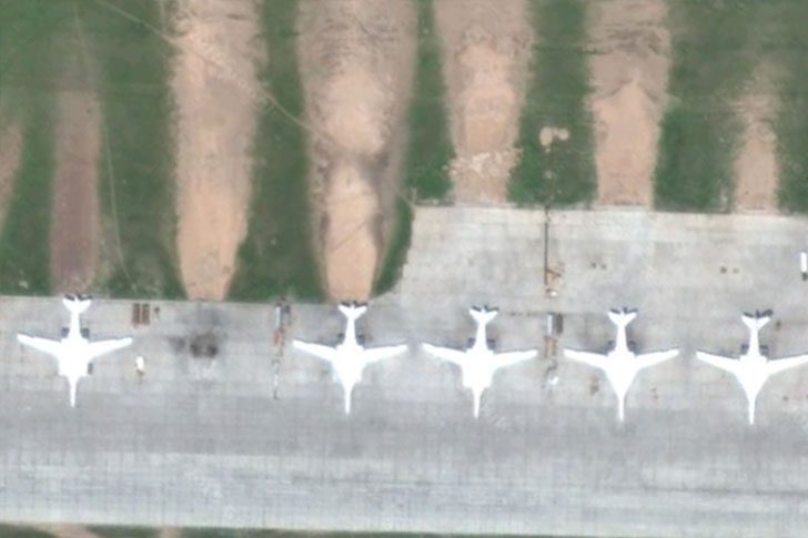
You really do not want to be near the back of these fighter jets. This photo is a public service announcement about how brutal jet engines can be. The grass behind them is not just flattened; it is shredded and scorched like someone used a giant blowtorch and sandblaster at once. Those chewed-up spots result from insanely hot exhaust blasting the soil and turf.
Everyone knows jets are powerful, but seeing this aftermath is wild. Hearing about thrust is one thing; watching green turn into a wrecked strip in seconds is another. In this image, several aircraft's signatures are evident, and the message is clear: that grass did not stand a chance.
This Google Maps “Alien” on a French Balcony Is Way Creepier Than It Should Be

Zooming around Nancy, France, on Google Maps, might surprise you with a spooky, human-shaped figure standing on a terrace. This figure sports giant pale eyes and wiry hair, and screenshots of it quickly spread online, sparking widespread fascination. Google later blurred the entire house. Despite being probably harmless, the image is undeniably chilling.
The simplest explanation is that it’s a tiki statue catching light oddly. Yet, paranormal enthusiasts speculate something stranger. Perhaps the eerie little figure desired privacy, or the homeowner wanted to deter curious visitors knocking with questions like, “Hi, can we talk about your Tiki Demon?” The blur, however, only heightens suspicion.
Why This Lake Near Sadr City Looks Like a Pool of Blood
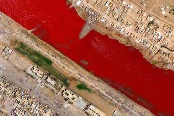
Just outside Sadr City in Iraq, there’s a lake with water showing an intense, blood-red color. No official report has provided a definitive explanation. When people noticed this in 2007, rumors spread quickly. One person told Boing Boing that local slaughterhouses sometimes dump blood into nearby canals, supposedly based on hearsay. Creepy, but unconfirmed.
Even without a formal statement, the most likely cause is less dramatic. In warm, salty water, certain algae and bacteria thrive, and some tint water red as they bloom. With the right mix of heat and salinity, a lake can turn into a giant petri dish, staining the surface a deep crimson shade. It looks sinister, but it’s probably just biology at work.
What’s Really Hiding in That Massive Airplane Graveyard?
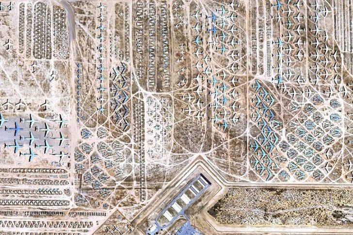
Ever wonder what happens when a plane is done flying? It doesn’t vanish into thin air. Recently, sharp-eyed Google Earth users found the answer outside Tucson, Arizona: Davis-Monthan Air Force Base. It hosts the world's largest aircraft boneyard, where U.S. military jets and other aircraft are parked, lined up like they are waiting for a flight that’s never boarding.
The story goes back to after World War II, when the base began stockpiling aircraft. Tucson’s dry, hot climate helps keep corrosion in check, making storage easier. Some planes sit intact, while others are dismantled for parts to keep other aircraft running. From above, the endless rows look eerie and perfect, but if you want to see it up close, you can book a bus tour.
Why This Japanese Yard Is Packed With Giant “People” Who Never Blink
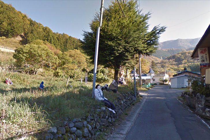
Google Earth captured this eerie scene in Nagoro, a tiny Japanese hamlet, and at first glance, it looks like a yard full of neighbors hanging around. Look again, though, and the vibe shifts fast. Those “locals” are oversized dolls, arranged like they are mid conversation or waiting for the bus. Instead of usual town square movements, you get a quiet crowd of stuffed scarecrows standing in for residents. It is spooky, a little funny, and strangely touching all at once.
According to NPR, the person behind the project is Ayano, who has been making these scarecrows for over a decade. She began crafting them as the village’s population shrank, using the figures to fill empty spaces left behind. Some are modeled after specific characters, while others serve as tributes to those who have passed away. The result is part art project, part memorial, and a reminder of what happens when a small town slowly empties out.
Why This “Steep Hill” on Google Maps Had Drivers Doing a Double Take
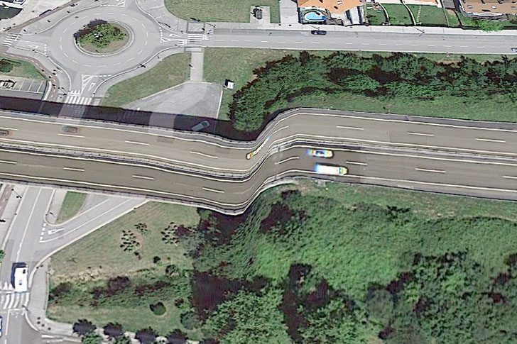
This odd stretch of road sits by the Oria River in Orio, a tourist town near the sea. No, the locals did not build a roller-coaster highway. As often happens, Google was the troublemaker, turning a normal route into something seemingly unsafe, causing chaos. It was not a steep slope, just a digital hiccup in Orio, Spain, during data processing.
It's fortunate this was a software bug, not reality. Still, imagine the nonsense if a road really dropped off like that: curious drivers, panic, cars rubbernecking. Such an extreme would be less “thrilling shortcut” and more “deadly trap waiting to happen.” Laugh at the glitch, then be grateful it stayed on the screen.
The Two-Legged Dog-Wolf Thing on Google Earth, What Is It?
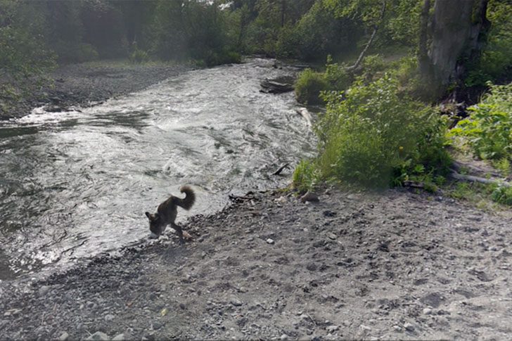
There’s a supposed dog-wolf hybrid prowling on two legs. Realistically, it seems like Google Earth having a glitch rather than a new species. Actor Aaron found the screenshot; it’s quite amusing. Captured in June 2016, Far North Bicentennial Park is the scene's location, ready to explore on Google Earth for those curious enough.
The fun begins when you zoom enough for user-uploaded 3D images to come into play. The scene bizarrely distorts, like the map attempts to render reality and bails out. It’s comparable to Dalí’s surreal art. The big question remains if the actual owner of this ordinary, four-legged dog ever realized their pet morphed into an online legend.
The One Island on Google Earth That Still Freaks People Out
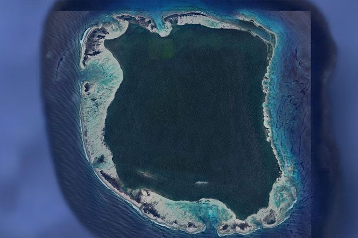
North Sentinel's appearance, all lush jungle and sandy edges, might seem ordinary at first. However, it's home to one of the last uncontacted tribes globally. No roads, docks, or modern constructs hint at "civilization was here." It's often likened to Manhattan, but North Sentinel remains untouched by outside influences, fiercely guarding its isolation.
The intriguing aspect is the lack of concrete knowledge about the place. We know its inhabitants wish to remain isolated and are defensive against outsiders, but specifics are scarce. This air of mystery continues to grow, keeping North Sentinel an enigma. Our visits are limited to flyovers and Google Earth views, observing a world separate in its isolated timeline.
The Tiny Antarctic Hut That Time Forgot
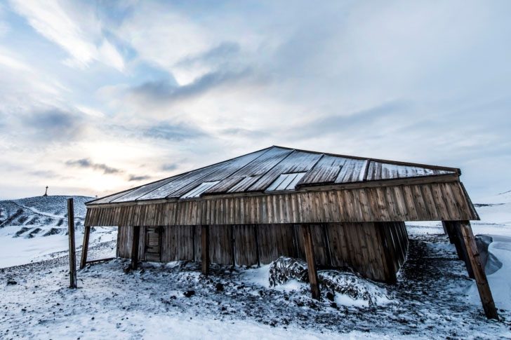
Scott's base is as simple as it sounds, located on Cape Evans, Ross Island, in Antarctica's stunning yet harsh environment. Built in 1911 for the British Antarctic Expedition (1910-1913) under Robert Scott's leadership, it served as a launch point into the icy continent. Remarkably, it's still there today.
Given Antarctica's unforgiving climate, New Zealand’s Antarctic Heritage Trust has reinforced it, repairing damage and sealing it from the elements. Inside, they preserved 18,202 artifacts, including clothing, food, and gear, as if awaiting their users' return. For an easy visit, Google Earth offers a detailed virtual tour.
The One Thing You Didn’t Expect to See Inside Scott’s Hut

Google Earth doesn’t usually let you peek inside random buildings, but sometimes breaks its own rules. This hut is one exception. Drop in virtually and explore without setting foot on the ice. Its cared-for appearance suggests someone might return any minute. Historic shelters like Shackleton’s Hut and this one, both used by Antarctic explorers, feel more like time travel than sightseeing.
Surprisingly, it still holds a snapshot of expedition life with preserved supplies. Food, medicines, survival gear, and equipment from those journeys remain, over a century later, looking eerily familiar. It’s sat empty for decades yet remains almost exactly as it was. No dramatic makeover, no modern clutter—just a frozen pause button on history, surviving years nearly untouched.
The Giant Guitar Forest in Argentina, and the Heartbreaking Reason It Exists
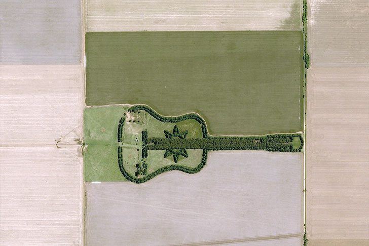
Drive through Argentina’s farmland, and you might spot something that makes you do a double take: a whole forest laid out like a guitar. It’s not a trick of the light. Pedro designed it, planting a woodland stretching close to two-thirds of a mile. The “strings” and curves are formed by more than 7,000 trees, mainly cypress and eucalyptus, arranged with impressive precision.
It wasn’t just for show. To keep the memory of his wife, Graciela, alive, Ureta and his children planted every tree themselves, transforming grief into a sky-visible tribute. Over time, this homage became a favorite sight for pilots and travelers. Thanks to Google Earth, even those never visiting Argentina can appreciate the design and love behind it.
Who Left This Massive Pink Bunny on an Italian Hillside?
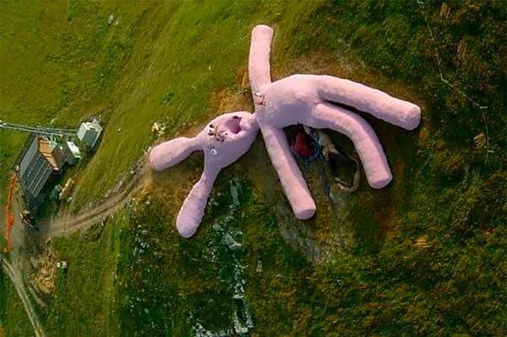
This odd surprise appears on Google Earth above Artesina in Italy’s Piedmont region. It's a gigantic pink rabbit by Gelitin, a Vienna collective known for turning “wait, what is that?” into a destination. Built in 2005, the bunny is mostly straw and wool. About a ton of wool went into its fuzzy “skin,” stitched by hundreds of elderly women.
If you’re hiking nearby, the scale can be a jump scare, and the face doesn’t scream “cuddly.” That unsettling vibe is part of its charm. People can climb on it, sprawl out, and treat it like a weird playground. Since Gelitin wanted nature to have the final say, they didn’t preserve it. Rotting, sagging, and slowly falling apart is part of the plan.
Why a Raised Bike on Google Earth Stopped Everyone in Their Tracks
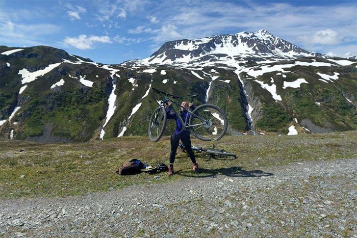
If you have ever hiked, biked, or paddled around Alaska, you know the vibe: huge sky, endless wilderness, and stretches where it feels like you have the whole place to yourself. A cyclist braved Alaska’s icy peaks and was captured by Google Earth at the perfect moment. Pedaling a mountain bike across snow is a feat; the camera caught her mid-celebration, hoisting her bike like she won the world’s coldest race.
From other angles, you see the same cyclist with a small group, enhancing the mystery. Did she notice the Google Earth car and seize the moment for a photo? The snapshot, taken in June 2017 near Seward, Alaska, turned her ride into an unintentional internet trophy moment.
Why This Car Looks Like It’s Driving Straight Into a River
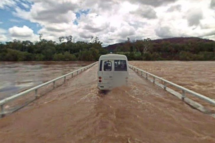
Rolling through Delamere, a Google Earth worker found himself in a situation beyond the usual “take a quick photo and move on” job. Delamere, in Australia’s Northern Territory, was heavily flooded. The scene ahead makes you double-take. The car looks like it’s crossing a river, but guardrails hint it’s supposed to be a road. When floodwater takes over, the line between highway and waterway disappears fast.
This isn’t the first time the area endured such conditions. A monsoon in early 2018 caused major flooding, leaving many drivers stranded. Hopefully, everyone was okay, as floods can be deadly. One misread of the road, a confident push forward, and suddenly you’re on an unplanned riverbed tour. It's a stark reminder: if the road looks like water, it likely is.
The Strange Thing Hanging in This Greek Sunrise Photo

The Greek island of Oia knows how to show off. While everyone raves about the legendary sunsets, sunrise here is just as unreal. Soft light spills over the caldera, with homes and restaurants carved into the sea-facing slope. Stacked along the steep cliffs, it feels like nature built Oia, and people simply moved in.
Famous cave houses are cut into volcanic rock along the Caldera cliffs. Known for its beaches, expansive views, and unbeatable seafood, Oia surprises with rows of octopi hanging out to dry. It’s like a dramatic “dinner is coming” sign, setting tonight’s menu straight from ocean to table.
The Google Earth Snapshot That Shows Something Wild in a Coffee Shop
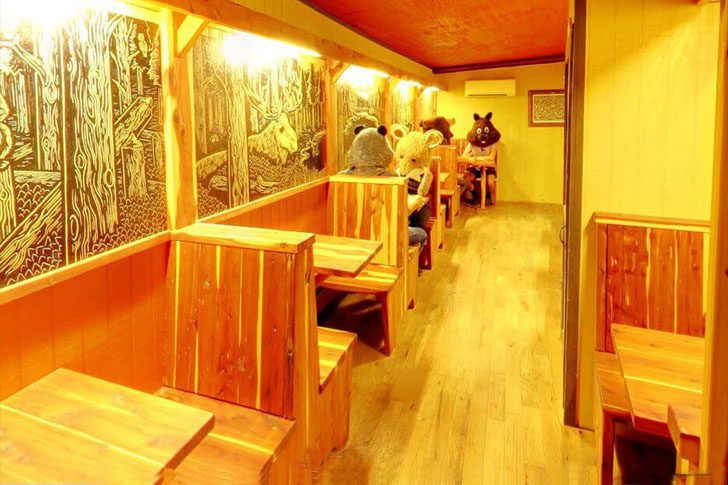
Need a place to kick back with friends, grab a drink, and inexplicably suit up as an animal? The Buzz Mill has you covered. This Google Earth capture makes you squint and ask, “Wait, is that real?” A well-known spot in Austin, Texas, is where this surprise was recorded. It lands somewhere between hilarious and mildly unsettling.
Google Earth actually ventures inside, starting with a cozy cafe vibe. Then you turn toward the gaming area and suddenly, there are people in full-on animal costumes hanging out like it's ordinary. You have to explore the virtual tour a bit to spot them, which makes it funnier. One moment you explore a cafe, the next you're watching costumed creatures sip coffee.
The Weird Reason This “Battleship” Island in Japan Still Looks Frozen in Time
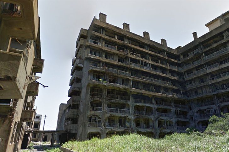
Hashima Island, better known as Gunkanjima, sits off Nagasaki Prefecture like a concrete time capsule. Once a packed little world built around coal, the island saw around 5,000 people living closely together. From the late 1800s, it developed into a mining hub until the coal industry's decline led to its closure in the 1970s, leaving it abandoned. Public tours began only in 2009.
Google has offered 360-degree views for online visitors. Some images from Google Trekker even explore areas beyond typical tourist paths. That's where the island gets extra eerie: you can spot old black-and-white TVs, stray empty soda bottles, and rooms that seem frozen in time. It’s part history, part urban ghost story, all from your screen.
The Wild Thing Sitting on Mauna Kea’s Summit in Hawaii
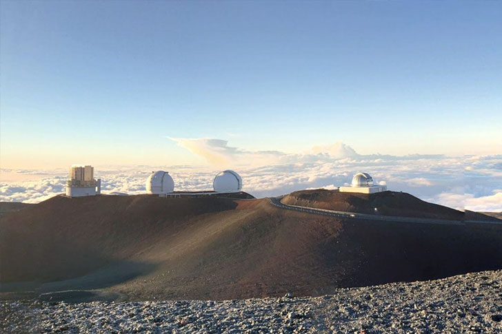
It barely looks like Hawaii up there, but it absolutely is. At 13,802 feet, Mauna Kea on the Big Island is the state’s highest point and a towering island peak on Earth. The sci-fi-like buildings near the top are the Mauna Kea Observatories, where scientists conduct research using the thin air and clear skies.
The main facility features twin 8.1-meter telescopes. These instruments, together, cover the entire sky and are among the most powerful optical and infrared tools. On a good night, they capture faint light from deep space, aiding in studying distant galaxies and nearby objects.
The Google Earth Shot That Shows Hawaii’s Lava Scar Up Close
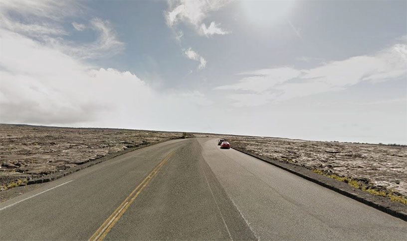
Volcanoes can swiftly devastate areas, but seeing the aftermath is sobering. This section of Hawaii’s Big Island was buried by lava years ago; the view on Google Earth appears almost surreal. The dark lava flow seems to have obliterated everything. Newer roads trace the hardened edge, hinting at human adaptation. It’s a quiet nod to a past that was neither empty nor still.
Hawaii’s very existence is due to volcanic activity, which forged the islands over millions of years. These forces continue to mold the landscape we cherish. Yet, when lava erupts in large volumes, it’s not just dramatic but also economically devastating. This event remains one of the U.S.'s most destructive volcanic property losses, leaving an indelible mark on the land.
The Strange Circles in Egypt’s Desert Have a Very Human Explanation
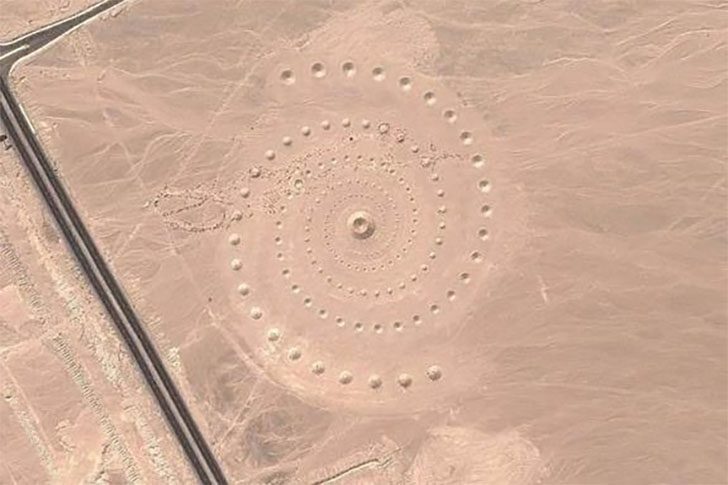
When drivers first noticed a neat field of circles in the sand off a road in Egypt, many thought of sci-fi. It resembled desert crop circles, seemingly a message from afar. In reality, it's a land art installation by D.A.ST. Arteam, three Greek artists designing it as a massive, walkable artwork.
Painter Danae Stratou explained that the desert inspired them. “The desert, in our minds’ eye, was a place where one might feel eternity. We were talking about the desert as a mental condition, a mental landscape.” The project, named Desert Breath, remains out there today, gradually softening as wind and time blur its edges, which is part of the intent.
What’s That Dark River on Google Earth? It’s a Buffalo Herd
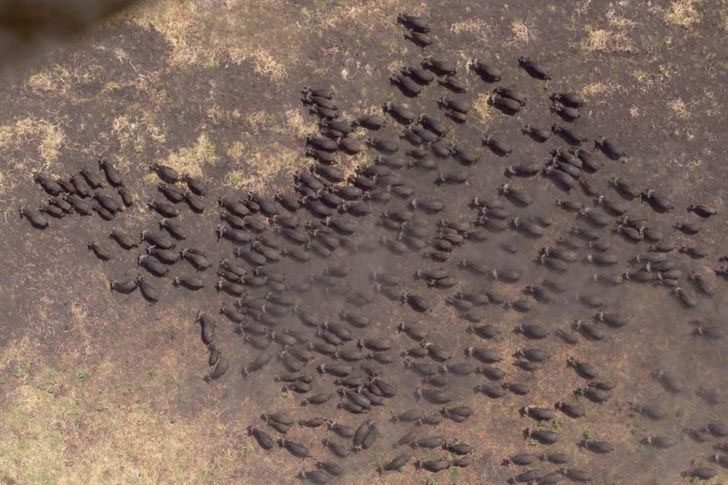
Zoom in on Tanzania’s Kigosi Game Reserve, and you may notice a mysterious, moving dark streak. Closer inspection reveals this shadow is a massive herd of buffalo traversing the plains. Kigosi teems with wildlife, including rare animals and birds, and offers safaris and guided trips. However, seeing such a densely packed herd via satellite images is a rare spectacle.
African buffalo are large, heavy creatures, comparable in size to North American bison. However, these animals are known for their unpredictable and dangerous demeanor, reportedly injuring over 200 people annually. Observing them from a safe distance using Google Earth allows for an impressive spectacle minus the risk.
This Oregon Cornfield Had a Giant Firefox Logo, Here’s Why
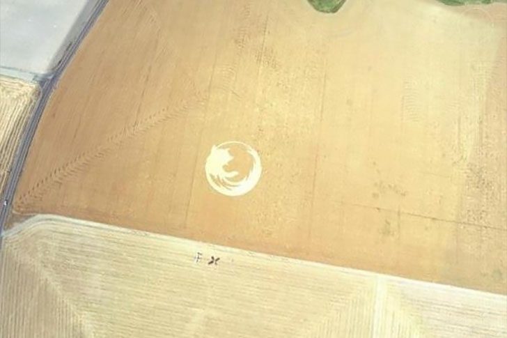
This crop circle in an Oregon cornfield resembles an “alien message” but is straightforward. There is no mystery, just enthusiastic browser fans. Branding crops is a bold loyalty statement. Created in 2006, the design took fans about 24 hours to carve out.
The oversized logo marked 50 million downloads. The Oregon State University Linux Users group managed the project, transforming a field into a 45,000-square-foot tribute spanning 220 feet. From the road, it appears as a regular corn patch, but from above, the giant emblem is unmistakable.
The “Ocean” You’re Seeing on Google Earth, That’s Actually a Swimming Pool
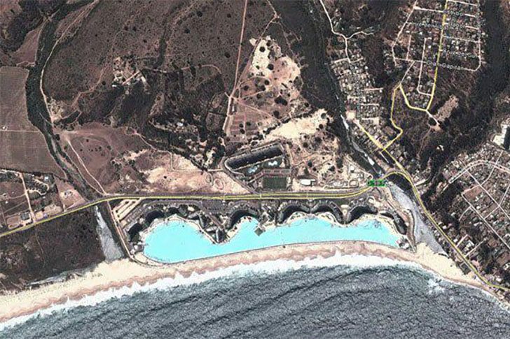
People exploring the Chilean coastline on Google Earth might be startled by a second ocean beside the real one. It’s not an optical illusion; that blue expanse belongs to the San Alfonso del Mar resort in Algarrobo, Chile. The ocean is actually a man-made swimming pool, boasting the title of the largest pool on Earth.
This pool is enormous: about 3,324 feet long, covering roughly 19.77 acres, and holding around 66 million gallons of water. If swimming excites you, this destination belongs on your bucket list. From above, it seems surreal, resembling the sea transplanted into a resort. Witnessing it in person must be even more astonishing, given the proximity of the actual ocean.
The “Island” That Looked Like a Black Polygon on Google Earth
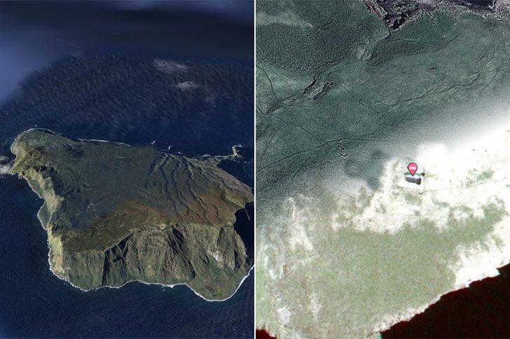
If your neighbors treat midnight like prime time, and every parking spot feels competitive, the fantasy solution is clear: disappear to a remote island for peace and quiet. That dream took an odd turn in the South Pacific when researchers in 2012 “undiscovered” an island the size of Manhattan. It had appeared on maps for ages, even though it wasn't real. For solitude lovers, it was the ultimate address until reality intervened.
On Google Earth, it appeared as a solid black polygon. In April 2013, researchers published an obituary for this phantom landmass, explaining how it haunted maps for over a century. They attributed this to human error and a strange natural phenomenon: a drifting pumice raft that may have fooled earlier observers. Thus, the “island” was less a hidden paradise and more a cartography glitch.
The One Scooter Snapshot on Google Maps You Can’t Unsee
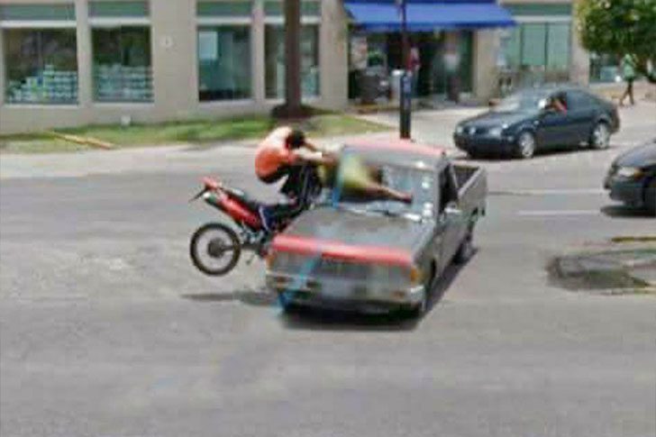
In Tlaquepaque, Mexico, 2015, a Google camera immortalized a cringe-inducing moment. A scooter rider clips a car and tumbles down, a scene that makes viewers wince. It’s amusing how “natural” photos capture your oddest angles, akin to candid snapshots at weddings. Google Maps, the world’s largest accidental photo album, operates on this principle but with a wider reach.
Also in view, two motorcyclists crash into a pickup truck. One sprawls across the glass, and the other hangs mid-air as if suspended in a stunt. The background intensifies this bizarre tableau—pedestrians stroll by, unfazed. Despite the crash unfolding in plain sight, their indifference is chilling. It's a stark reminder that street-view cameras document more than locations; they snapshot real life, moments you might prefer to erase.
This Little Green “Slow” Sign Might Be the Traffic Guard We Actually Need
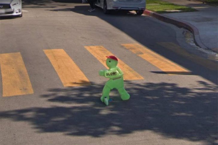
Admit it, many of us have daydreamed about having a fictional sidekick in the passenger seat, especially on days our right foot gets overconfident. That tiny green humanoid looks like it could talk its way out of anything, and if you get pulled over for speeding, its improv skills could come in handy. Plus, it feels kinder than the usual scolding. Drivers might be less annoyed rolling through a light when the “cop” is a cute alien mascot.
I'm over the concept of a human crossing guard waving me around like I'm in traffic school. Give me a small green humanoid sign saying “slow,” meant to stand in for a child, and let that be the vibe. It’s simple, charming, and might work better because nobody wants to disappoint the tiny green guy. Sure, you might do something dumb and end up in jail, but hey, that’s part of the thrill, right?
This Passenger Jet on Google Maps Looks Like a Pixelated Glitch
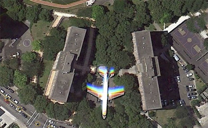
While Google’s satellites were capturing imagery, they accidentally snapped a jet mid-flight, looking like a video game bug. Brooklyn photographer Christoffer discovered the peculiar sight, noticing a plane seemingly integrated into the Bushwick Houses area. He shared the screenshot, which looks like something your graphics card might produce before crashing—crisp in some spots, and trippy in others.
You can see the same aircraft on Google Earth and Maps, with a capture date of June 18, 2010. A close zoom on Google Earth shows the jet hovering above trees, with rainbow-like streaks trailing it. The most likely explanation is tech physics: the plane was moving faster than the satellite camera’s shutter speed. Instead of capturing a normal jet, it resulted in a psychedelic smear, as if reality briefly lagged.
The One Google Maps Screenshot That Exposed a Parking Lot Hit-and-Run
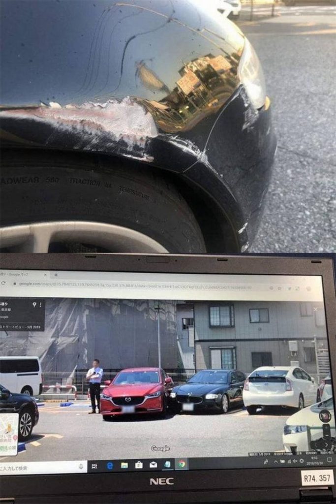
A Maserati Quattroporte took a nasty hit in a Times parking lot in Adachi-Ku, Tokyo, and Google Street View was there for it. The damage appeared on the right front corner, caused by a red Mazda that clipped the luxury sedan and drove off. For once, the camera car wasn’t just collecting scenery; it recorded an expensive problem in real time.
The owner realized it only after leaving the office, finding the front end smashed with no contact info left. Initially, it seemed like another frustrating mystery. However, while using Google Maps later, they discovered a Street View image that captured the moment the car was struck.
The Lawn Mower Photo on Google Maps That Turned Into a Surprise Family Snapshot
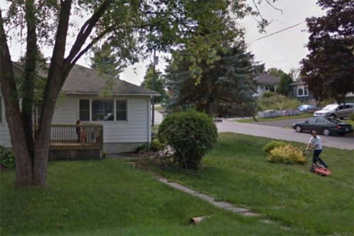
There he is, dressed like he could be heading to the office, white shirt, black pants, yet pushing a lawnmower. Parked beside a strip of grass, it’s the kind of everyday scene you’d walk past without a thought. It’s simple, ordinary, almost boring, until you realize this isn’t a random phone photo. It’s a Street View moment, frozen online.
Here's the funny part: Brown didn’t find this picture on purpose. While checking out his place on Google Maps, he suddenly spotted himself mowing. Then he noticed something endearing: his kids had wandered outside to watch him, turning a basic yard job into a family gathering. He didn’t know they’d been there, and Google accidentally preserved it anyway. Not a bad surprise to find online.
The One Google Maps Snapshot That Caught a Balcony Surprise

Street View cameras, typically perched atop Google cars or carried by Maps workers, quietly capture candid moments. Often, they snap real people unexpectedly, revealing scenes not intended for the web.
On a sunny day, a man in a blue shirt stood on his balcony, seemingly awaiting a parade. The uploader heard him yell, “It’s here!” like a child spotting an ice cream truck. Checking his own place on Google Maps later, he found his neighbor's balcony moment immortalized in Street View.
The One Finland Map That Explains All Those Sauna Pins
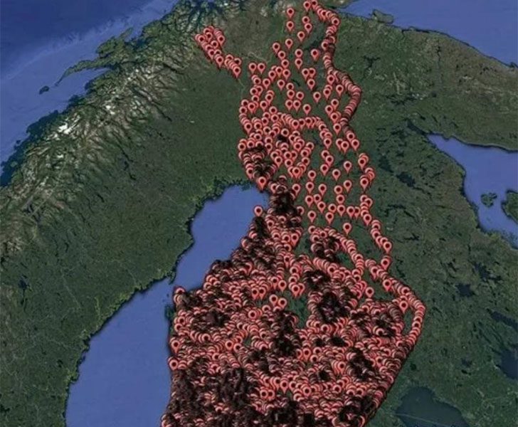
If you need another reason to visit Finland, a map brimming with public sauna locations might be it. Beyond its stunning landscapes and clean urban spaces, its sauna culture stands out. Picture pinpointing sauna spots, turning travel plans into a treasure hunt, and transforming “someday” dreams into concrete routes.
While saunas are global, in Finland, they're deeply ingrained in the culture. Historically vital, especially in harsh winters, they offered warmth and a place to wash before indoor plumbing. Tales even mention babies born in saunas, though not directly in the heat. Today, saunas remain a wellness and social ritual, embodying Finnish life.
Why Two Guys in Kilts With Swords Showed Up on Google Street View
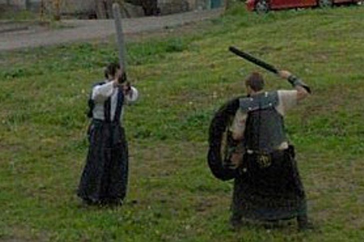
This is one of the best things Street View has accidentally given the internet: suburban warriors, fully armored, dueling with swords. Whether they're hardcore reenactors living their best life or time-traveling medieval people settling a score, it's unclear. Sadly, the Google car moved on before we saw the outcome, leaving the finale shrouded in mystery.
You've got to admire the dedication. Timing was spot-on, their stances looked genuine, and the kilts added an extra flair, as if they knew they’d be immortalized. Whether planned or pure chance as the Street View car drove by, it's comedy gold. We may never know who these guys are, but their spectacular, unnecessary duel is forever preserved in the world’s most random digital scrapbook.
Why Is There a Frying Pan on This Guy’s Face?
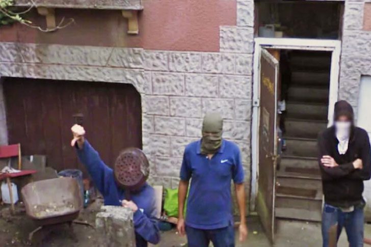
Honestly, we have no idea what we’re looking at here, and that’s what makes it so unsettling. Google Earth is great at capturing jaw-dropping scenery, but sometimes it freezes a moment that feels like a weird dream. Stumbling onto this crew after dark would prompt a universal “nope” and a quick exit. The real scene stealer is the one person rocking a full-on pan across his face like it’s protective gear.
Trying to look intimidating while wearing cookware is bold, if not exactly brilliant. Where were his friends when he made this choice? They give off tough-guy energy, and then there’s him, looking like he just wandered out of a kitchen brawl. Instead of adding menace, the pan turns the vibe into accidental comedy, like someone tried to cosplay a street brawler and grabbed the nearest thing from the stove.
What Happened to Gumby in This Photo Is Honestly Wild
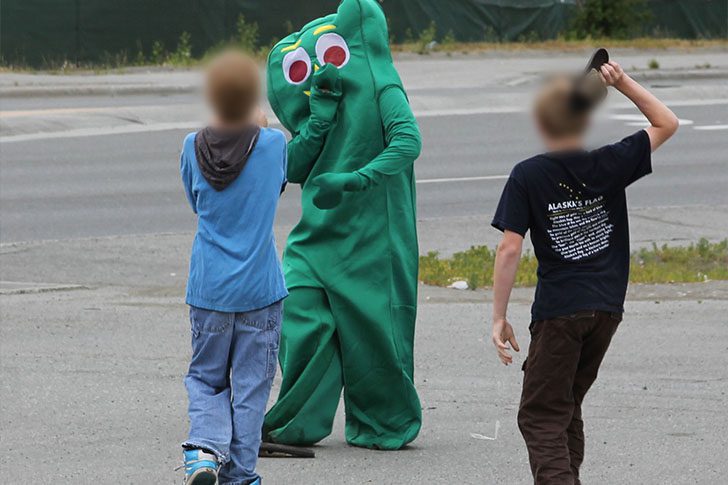
No location tag, just an image that feels like it wandered out of childhood into a strange crime scene. There's the character, supposedly a hero, getting manhandled by two kids who think he's fair game. The funniest part is he's bigger than both of them and in a suit, yet his vibe screams panic. It's a snapshot of how mean kids can be. Bullying doesn’t even stop at cartoon icons.
Sure, it’s two against one, but the “two” are just children. In a worst-case scenario, the actor could decide he’s done being a punching bag. He can bolt, stand there, or flip the script and start handing out the pounding instead. Either way, the photo reminds us nobody’s truly safe, not even a bendy green favorite from childhood.
The One Satellite Photo of a Dutch Pier That Had Everyone Freaking Out
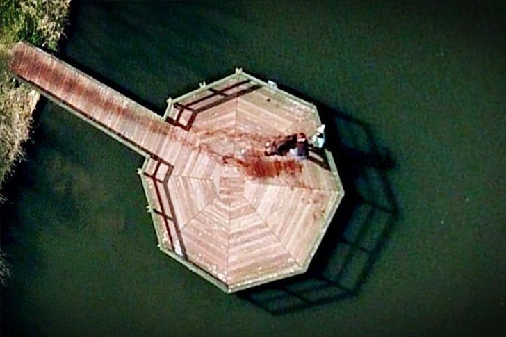
At first glance, this looks like a still from a gritty Law and Order teaser. People tracked the coordinates and landed on a dock at a public park in the Netherlands. Then the internet spiraled. In the satellite shot, it seemed like someone was dragging a body to the end of the pier, complete with a dark streak behind them. The vibe was so ominous that plenty of folks were convinced they’d stumbled onto something truly horrifying.
But after web detectives zoomed, compared angles, and investigated from their couches, the story got less sinister. It wasn’t a crime scene at all. It was just a couple out with their dog, taking a swim and dripping water on the dock's boards afterward. That “black blood trail” was wet wood and shadow, nothing more dramatic than a soggy walkway drying in the sun.
The One Street View Photo That Turned a Google Car Into a Crime Scene
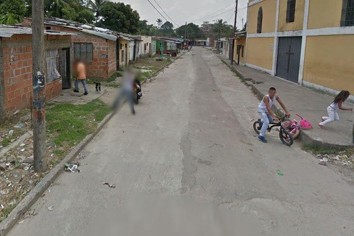
Here’s a wild snapshot: a resident is seen aiming a large weapon at a Google car, and Google later blurred the gun out. The scene feels darker knowing a 17-month-old child was found dead months earlier in what appears to be the same house. What seems like a random Street View moment suddenly hints at something much more serious—details you don’t expect while exploring a map.
The unsettling part is this image, captured by Google Earth, could be evidence in court. Google Earth uses cameras mounted on Google-branded cars to document streets globally. In Villavicencio, Colombia, one local clearly didn’t appreciate a Street View vehicle in his area. The camera immortalized a tense moment that may extend far beyond the internet.
The Creepiest Thing You Can Spot on Google Earth, a Lone Skull
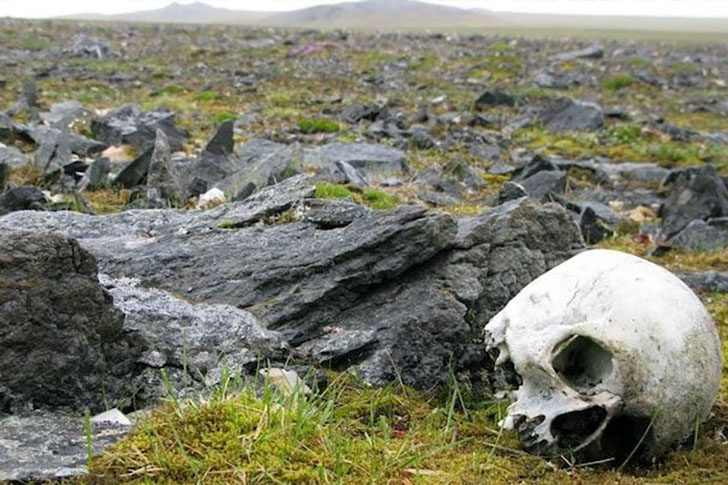
When scrolling feels endless, try a different kind of sightseeing from your couch. Pull up Google Earth and head over to Novaya Zemlya, Russia. It is remote, icy, and the opposite of a tourist hotspot. Zoom in enough, and you might notice something startling: a human skull in plain sight. Creepy, yes, but also oddly fascinating.
Why is a skull out there? The lack of an official explanation adds to the unease. This area is rich in heavy history, being a major USSR nuclear testing site. It’s where the Tsar Bomba detonated in 1961, still the most powerful nuclear test in history. You can take the virtual tour, but be ready for fast vibe changes, from empty tundra to an unexpected mystery.
Why Are There Finger Guns in This Google Street View Shot?
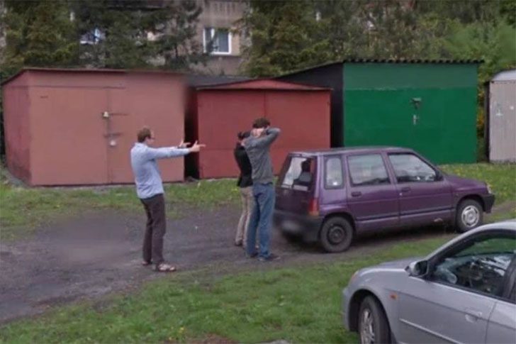
A Google Street View car rolled by at a serendipitous moment, capturing an amusing scene resembling a first-world “armed” robbery. In the frame, two people stand in a classic “don’t shoot” pose while a man, instead of wielding a weapon, amusingly points finger guns at them. Behind them, a car and a few individuals are visible as the Street View vehicle passes by.
As the camera moves, the faux robber pulls the pair out of their car, seemingly unbothered by the filming. By the time the Google car reaches the end of the road, the scene vanishes from view. It is unmistakably a hold-up, but the “weapon” being mere fingers adds a comically absurd twist to the scenario.
Why Are Some Google Local Guides Getting Holiday Socks in the Mail?

Local Guides quietly enhance Google Maps, crafting neighborhood lists and tips for visitors. To express gratitude, Google occasionally offers surprises. Currently, some Guides are getting holiday socks, acknowledging their map-improving efforts.
Social media posts indicate the giveaway's authenticity. The socks feature landmark graphics and Local Guides on the bottom, coined as a “gift for your next journey.” Not everyone receives them, suggesting a selective distribution. As giveaways go, socks are a practical and appreciated gift.